[donotprint] These pages are for readers of Bikepacking: mountain bike camping adventures on the wild trails of Britain by Laurence McJannet.
If you do not own the book please buy a copy here![/donotprint]
[print_link]
Ride Information
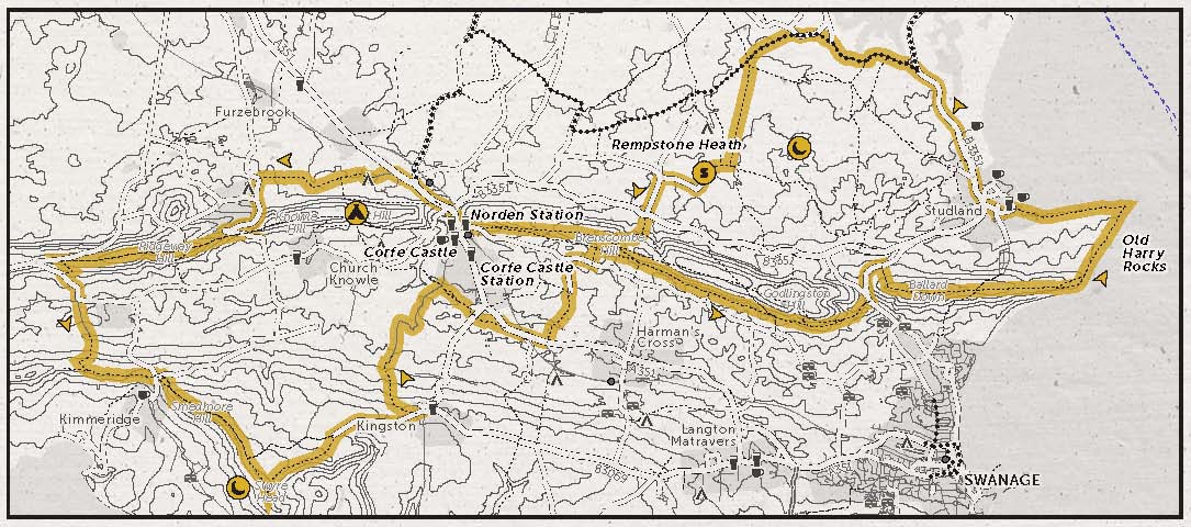
START/FINISH: National Trust and Bankes Arms car park, Manor Road, Studland BH19 3AU, 50.641745, -1.946943
DISTANCE: 27.3 miles/43.9km
ASCENT: 3129ft/954m
OFF-ROAD: 80%
TERRAIN: Wide chalky doubletrack, forest and wooded singletrack, some grass and tarmac sections. Climbs tend to be long rather than steep.
NAVIGATION: Occasionally tricky. At the end of the track up to Ridgeway Hill, make sure you go through a gate to your left before continuing west, with the fence on your right. Following NCN Route 2 through Rempstone Heath, you will come to a staggered junction of five paths; don’t follow Route 2 straight on here but take the second trail on your left to head due south. OS Landranger 195 could be useful.[donotprint]
Maps
Ordnance Survey Map
[osmap height=”400″ width=”auto” color=”red” gpx=”https://www.wildthingspublishing.com/wp-content/uploads/bikepacking/Bikepacking Ride No.4_Purbecks.gpx”]
Open Street Map with information markers and elevation
Book Map[/donotprint]
 [donotprint]Downloadables
 [donotprint]Downloadables
Download .GPX file (right click to download)
Download map.pdf from the book (right click to download)
How to navigate using .GPX files[/donotprint]
Eat & Drink
The Scott Arms, West Street, Kingston, Wareham, Dorset BH20 5LH, 01929 480270, www.thescottarms.com
Joe’s Cafe, South Beach, Studland, Dorset BH19 3AN
Sleep
Olivers of Corfe Castle, 5 West Street, Corfe Castle, Wareham, Dorset BH20 5HA, 01929 477111
Camp: East Creech Farm, Creech, Wareham, Dorset BH20 5AP, 01929 480519, www.eastcreechfarm.co.uk
Bivvy: Newton Heath or Smedmore Hill
Provisions
Corfe Castle Village Stores, 25 East Street, Corfe Castle, Dorset BH20 5EE, 01929
481292
Charlie the Bikemonger, 5 Queens Road, Swanage, Dorset BH19 2EQ, 01929 475833, www.charliethebikemonger.com